
The morning sun was just beginning to kiss the rim of the Sangre de Cristo Mountains when I launched my drone above Galisteo Creek at Lamy this past June. At eighty-one, I've learned that the best light for capturing the soul of New Mexico comes in those precious moments when the world is still waking up, when the shadows are long and the colors run deep as an old cowboy's memories.
As the drone climbed higher, revealing the serpentine path of Galisteo Creek where it emerges from Apache Canyon into the vast expanse of the Galisteo Basin, I couldn't help but think about all the eyes that have gazed upon this very scene over the centuries. The creek, a ribbon of life threading through this high desert country, has witnessed more history than most places have a right to claim.
A Creek That Carries Stories
From my vantage point on the mountainside, watching the live feed from my drone, I could see how Galisteo Creek cuts its way through the landscape like a storyteller's voice winding through time. The water may run thin most of the year, but don't let that fool you—this creek has been the lifeline for countless generations, long before the first Spanish explorers ever set foot in this territory.
The Galisteo Basin native American pueblo sites stretch along this waterway like beads on a turquoise necklace, each one a testament to the ingenuity and persistence of the people who called this land home centuries before European contact. As my drone panned across the terrain, I tried to imagine what it must have looked like when these pueblos were thriving communities, smoke rising from cooking fires, children playing along the creek banks, and farmers tending their crops in the fertile bottomlands.
The archaeological evidence tells us that the Galisteo Basin was home to thousands of native Americans who built their lives around this precious water source. The Galisteo Basin Archaeological Sites Protection Act recognizes the incredible significance of these ruins, protecting what remains of a civilization that flourished here from roughly 1250 to 1680 AD. These weren't just scattered settlements—we're talking about major population centers, some of the largest pueblos ever built in the Southwest.
Through the Lens of Time
Flying my drone over this landscape, I'm reminded of how photography and videography can be time machines of sorts. Through my lens, I can capture a moment that bridges centuries, showing the same creek, the same mesas, the same endless sky that the ancient pueblo builders knew so well. The technology may be different—Lord knows those old pueblo architects never had to worry about FAA regulations for their construction projects—but the fundamental human desire to document and share our world remains unchanged.
The morning light revealed the subtle textures of the landscape below: the way the creek meanders through cottonwood groves, the geometric patterns of old agricultural terraces still visible after all these years, the strategic placement of pueblo ruins on elevated ground overlooking the water source. These ancient engineers knew exactly what they were doing when they chose their building sites.
Where Rails Meet Ancient Trails
There's something poetic about the way the modern Amtrak station at Lamy sits so close to these ancient travel routes. The Southwest Chief still rolls through here daily, carrying passengers between Chicago and Los Angeles, following a route that parallels much of the old Santa Fe Trail. Just as the pueblo peoples used Galisteo Creek as a highway through this country, later travelers—traders, settlers, adventurers—would follow the Santa Fe Trail through this same basin.
The Santa Fe Trail, that great commercial highway of the 19th century, brought a different kind of energy to the Galisteo Basin. Where once pueblo farmers had cultivated corn, beans, and squash in the creek bottoms, wagon trains would rest and water their animals. The trail didn't follow the creek exactly, but it passed close enough that many travelers would have seen the ruins of the great pueblos, perhaps wondering about the people who had built them.
I often think about those early trail travelers—dusty, tired, probably a little nervous about what lay ahead—catching their first glimpse of these ancient structures. Did they recognize the sophistication of the engineering? Did they pause to wonder about the daily lives of the people who had walked these same paths centuries before?
The Pueblo Builders' Legacy
The Galisteo Basin native American pueblo sites represent one of the most remarkable chapters in Southwestern archaeology. These weren't small villages—some of these pueblos contained over 1,000 rooms, housing communities that would have rivaled the size of many modern New Mexico towns. The largest, like San Lazaro Pueblo, covered acres of ground and stood multiple stories high.
What strikes me most about these sites is how they were positioned in the landscape. The pueblo builders understood this country in ways that took me decades to appreciate, even growing up on a ranch in the Kansas Flint Hills. They knew where the water would be reliable, where the soil would be most fertile, where the winds would carry away the winter cold and bring summer rains. They built with the land, not against it.
The people who lived in these pueblos weren't just surviving—they were thriving. They developed sophisticated agricultural systems, traded with communities hundreds of miles away, and created art and pottery that we still admire today. The turquoise mines in the Cerrillos Hills, just a few miles from the Galisteo Basin, provided material that found its way into trade networks stretching from California to the Great Plains.
A Researcher's Paradise
For those interested in learning more about these incredible sites, the resource at galisteo.nmarchaeology.org provides a wealth of information about the archaeological work being done in the basin. The research being conducted here is helping us understand not just how these pueblo communities lived, but how they adapted to environmental challenges, managed their resources, and maintained their cultural identity over centuries.
The protection of these sites has become increasingly important as development pressure grows in the Santa Fe area. The Galisteo Basin Archaeological Sites Protection Act was a crucial step in ensuring that these irreplaceable resources are preserved for future generations. As someone who has spent the better part of his life documenting the American Southwest through photography and video, I can't emphasize enough how important it is to protect these tangible connections to our past.
The View from Above
There's something humbling about flying a drone over landscape that has been continuously inhabited for well over 700 years. The aerial perspective reveals patterns and relationships that are invisible from the ground. You can see how the pueblo builders chose their locations not just for access to water, but for defense, for communication with neighboring communities, and for the best agricultural potential.
From above, the ruins of these great pueblos look like ancient cities—which, in many ways, they were. The geometric precision of the room blocks, the strategic placement of plazas, the sophisticated water management systems all become clear when you can see the whole picture. It's a reminder that the people who built these communities were every bit as clever and forward-thinking as any urban planners today.
Paulette's Perspective
My beloved Paulette, who has been my partner in exploring this magnificent country for over four decades, often reminds me that the best stories aren't just about the places we visit, but about the people who made those places meaningful. When we moved to Santa Fe in 2017, we were drawn not just by the beauty of the landscape, but by the depth of human history that permeates every corner of this region.
She's right, of course. The Galisteo Basin native American pueblo sites aren't just archaeological curiosities—they're the remains of vibrant communities where people lived, worked, loved, and dreamed. They raised their children here, celebrated their harvests, weathered droughts and floods, and created art that still speaks to us across the centuries.
The Continuing Story
As I watched my drone footage later that morning, sitting on the portal of our Santa Fe home with a cup of coffee and the morning light painting the Sangre de Cristo Mountains in shades of gold and rose, I thought about how this landscape continues to draw people seeking something deeper than what they can find in the cities.
The Amtrak passengers pulling into Lamy station, the hikers exploring the trails along Galisteo Creek, the archaeologists carefully excavating and documenting the pueblo sites—we're all part of the continuing story of this place. We're drawn by the same things that attracted the pueblo builders: the reliable water, the fertile soil, the big sky, and the sense that this is a place where human dreams can take root and flourish.
Preservation and Progress
The challenge for our generation is figuring out how to honor and protect this incredible heritage while still allowing for the growth and change that keeps communities alive. The Galisteo Basin Archaeological Sites Protection Act represents one approach—legal protection that ensures these irreplaceable resources won't be lost to development or neglect.
But protection is just the beginning. These sites need ongoing research, interpretation, and public engagement to remain meaningful. The work being done by archaeologists and documented at resources like galisteo.nmarchaeology.org helps ensure that the stories of the pueblo builders don't fade into obscurity.
A Morning's Reflection
As I packed up my drone equipment that June morning, I felt the familiar satisfaction that comes from capturing something beautiful and meaningful. But more than that, I felt connected to a much larger story—the story of human persistence and adaptation, of communities that flourished in this challenging but rewarding landscape.
The Galisteo Basin native American pueblo sites remind us that this land has always been home to people who understood its rhythms and respected its limits. They built communities that lasted for centuries, leaving behind not just ruins, but lessons about how to live successfully in the American Southwest.
From my perspective as someone who has spent eight decades learning to read the land—first in the Kansas Flint Hills, then in the mountains and deserts of New Mexico—I can say with confidence that there are few places that offer such a compelling combination of natural beauty and human history. The Galisteo Basin is one of those rare places where the past and present converge in ways that enrich our understanding of both.
The morning light that illuminated Galisteo Creek that June day was the same light that warmed the faces of pueblo children seven centuries ago. The water that flows through Apache Canyon today nourished the crops that sustained thousands of people long before the Santa Fe Trail was even a dream. In capturing these moments through drone photography and videography, I'm not just documenting the landscape—I'm participating in the ancient human tradition of bearing witness to the enduring beauty and significance of the places we call home.
As Paulette and I continue to divide our time between the summer splendor of Santa Fe and the winter warmth of Lake Mohave, I'm grateful for the opportunity to explore and document these remarkable places. The Galisteo Basin native American pueblo sites represent just one chapter in the epic story of the American Southwest, but it's a chapter that deserves to be read, understood, and preserved for generations to come.
The drone may be modern technology, but the story it helps us tell is as old as the hills themselves—a story of people finding home in a landscape that challenges and rewards in equal measure, a story that continues to unfold with each sunrise over the Sangre de Cristo Mountains, each flight over Galisteo Creek, each moment of recognition that we are part of something much larger and more enduring than ourselves.
The Lamy Junction Community is a group of 14 small Coalition-era (A.D. 1200 - 1325) structures and pueblos that occupy the SE facing slope northwest and above the Rio Galisteo near the junction of US Highway 285 and Santa Fe County Road 33.
The dominating topographic feature of Cerro Colorado is immediately across the Rio Galisteo. The property is currently owned by the County of Santa Fe. Adolph Bandelier noted the area in his journal for June 29, 1882 where he mentions “a group of small house ruins” west of the depot at Lamy. Nels Nelson worked in the area in 1915, excavating 9 rooms at LA27, the largest pueblo in the community, and 7 rooms in other structures. Mera recorded seven of the smaller sites (LA362 through LA368) in the 1930s and Regge Wiseman recorded these and five more (LA31774 - LA31779) in August of 1981.
The general area of Lamy Junction apparently has been a cross road for the last century, possibly longer. At least four road beds crisscross the property, probably roads between Lamy and Galisteo, Lamy and Clines Corners, and  Galisteo/Clines Corners and Santa Fe. For this recording episode these roads and associated artifacts were considered as impacts upon the prehistoric sites, but they would be worth considering in their own right. The grade of the AT&SF/Burlington Northern railroad runs along the bed of the Rio Galisteo to the southeast of the Community. Railroad construction pushed the river over to the east, so it is now on the far side of the railroad grade from these sites.
The sites in the Lamy Junction Community are quite similar to one another. All appear to have been built of adobe with some stone and, except for LA27, to have held no more than 20 rooms, and most probably had less than 10. LA27, the largest, could have held 60 or more rooms, with at least part of the structure being two, possibly three stories high.
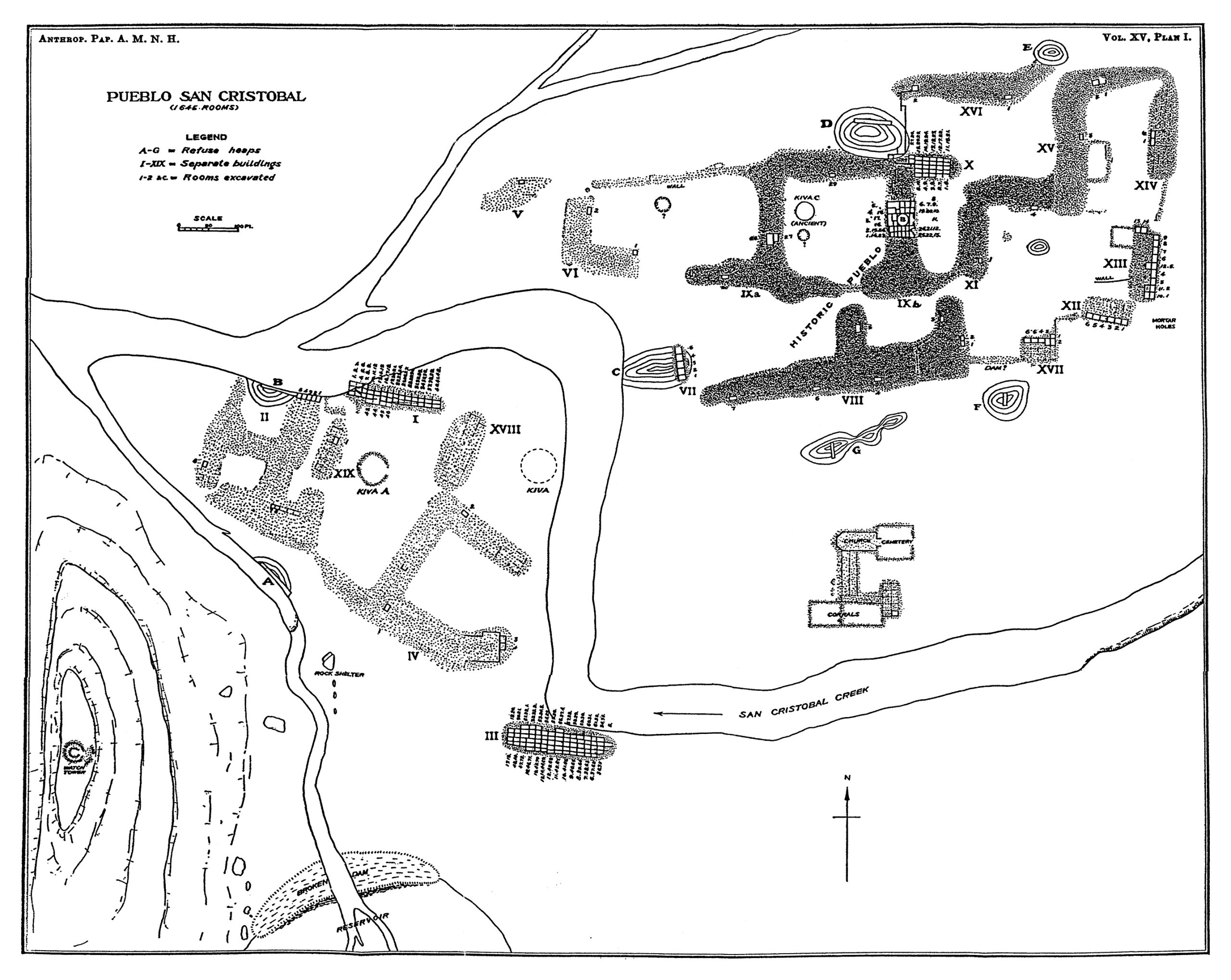
The impressive Pueblo San Cristóbal (LA 80) was the first and most extensively excavated of the sites studied by Nels C. Nelson in 1912.
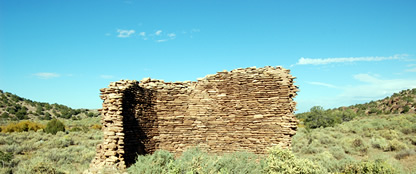
It differs from many of the pueblos in the Galisteo Basin in its greater use of stone as a building material. It is also noteworthy for its prolific rock art in the adjacent boulder field and cliffs and for the Spanish convento with church wall standing 4 m high. It is on the banks of the Arroyo San Cristóbal, a permanent water source. Nelson identified seventeen roomblocks and estimated 1,645 rooms. He made one of his remarkable maps (1914: Plate I), which also shows a shrine, six middens, eleven plazas, and a reservoir. Nelson excavated 227 rooms (Nelson 1914:113–119), including most or all of Roomblocks I (40 rooms) and III (72 rooms) south of the creek and large numbers in IXb (30 rooms), X (27 rooms), and XIII (12 rooms) up the hill in what he termed the historic pueblo. As was his practice, he excavated at least one room in each roomblock he identified.
Since Nelson (1914) the pueblo has attracted considerable attention, although little or no subsequent documented excavation. Publications include photographic and historic accounts (Mednick 1996), stabilization (Breternitz 1988), and a nomination to the National Register of Historic Places conducted by R. W. Lang in 1977 for the School of American Research (SAR). The SAR conducted a survey in the area of nearly 4,000 acres in 1976 and 1977. Lang’s project divided the site into a number of separate site numbers for various features, such as the roomblocks, the reservoir (LA 28423), the rock art (LA 28553, LA 28578, LA 28579). They recorded a series of tipi rings (LA 28360–LA 28371) outside the cross-mesa wall. The SAR also conducted stabilization in 1977, placing plates in the church wall (SC-SAR-R2F10). Friends of Archaeology and members of the Office of Archaeological Studies staff studied and documented changes and current state of the convento wall.
Museum studies of material include Sullivan analyses of skeletal material collected by Nelson. The OAS, under the auspices of the Galisteo Basin Initiative, has performed detailed  topographic mapping of the church and convento area. The presence of the mission at this pueblo makes it an outstanding place to study the earliest European–Native American contact. The pueblo was probably in decline at the time of the Spanish establishment there. The pueblo’s residents had an active role in the Revolt of 1680. The pueblo ceased to be occupied after the revolt.
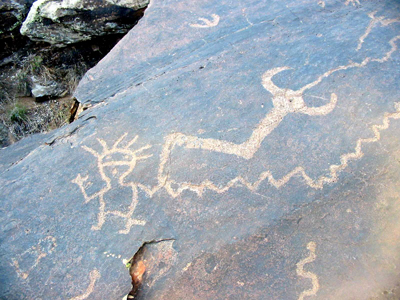
The rock art on the cliffs and in the boulder field north of the pueblo is extraordinary in its variety, abundance, and diversity. This area is often referred to as “world class,” about which there can be little debate. The images from this area are widely known and published (e.g., Mednick 1996; Slifer 2000:155; Schaafsma 1995). The majority of the panels in this area are Puebloan, but examples from earlier periods—the Archaic—are also present.
In addition rock art, the site has a number of other features. Around 100 m from the northeast corner of the roomblocks there is a wall made of huge sandstone slabs set on edge (DSC 1048). This wall crosses the entire mesa between the large drainage that bounds the north side of the pueblo and Arroyo San Cristóbal. Like the surrounding wall at Pecos Pueblo and perhaps the long east wall at Pueblo She, this wall may have demarcated the area outside of which visiting groups were required to stay. There are small enclosures within the wall, and figures are cut into the exposed bedrock near the south end of the wall.
Southwest of the pueblo there is a large flat area cut by some shallow drainages. One of these was dammed by a sizable construction. This area seems  almost inevitably to have been an important agricultural area for the pueblo. Further south of this area there are a few cultural features, including small artifact areas and cut logs.
As a well-watered location, the area around Pueblo San Cristóbal also has a number of historic features. A major irrigation ditch skirts the south and west sides of the pueblo on the north side of the creek and cuts a number of deposits. It passed between the church and the roomblocks and then crossed the major arroyo below the rock-art field by means of an aqueduct structure. This ditch was fed by a now-breached dam, and a heavy-duty head gate remains in place. The ditch was apparently abandoned by the time Nelson worked at the pueblo in 1912, but he did not map it (see Nelson photo comparison).


0 Comments