
A morning flight over sacred waters and the whispers of time
The pre-dawn air was crisp this late June morning as I prepared my drone for what would become one of those flights that stays with you long after the rotors stop spinning. From our Santa Fe home, the pull toward Galisteo Creek at Apache Canyon had been nagging at me for weeks—that familiar photographer's intuition that tells you when light and landscape are about to conspire for something special.
At eighty-plus years, I've learned to trust these feelings. They've guided me through decades of capturing the American Southwest's raw beauty, from my boyhood rambles across the Kansas Flint Hills to these golden retirement years that Paulette and I have carved out between our Angel Fire mountain retreat and these high desert summers in Santa Fe.
Following the Ancient Waters
Galisteo Creek doesn't look like much to the casual observer—just another modest waterway threading through New Mexico's high country. But as I launched my drone into the soft morning light, watching it rise above the cottonwoods and chamisa that line the creek's banks, I was struck again by the profound truth that water writes the deepest stories in this arid land.
The creek emerges from Glorieta Pass like a silver ribbon unfurling across time itself, carrying with it the memory of countless generations who have depended on its life-giving flow. Through my drone's camera, I could see how the landscape opens up as the water leaves the confines of Apache Canyon, beginning its journey toward Lamy and the vast Galisteo Basin beyond.
From this bird's-eye perspective, the geography tells its story with startling clarity. The creek follows an ancient course, carved over millennia through sedimentary layers that speak of prehistoric seas and volcanic upheavals. But more than geological time is written in these waters—this is where human history begins to layer itself thick as the alluvium along the banks.
Voices of the Ancestral Pueblo People
As my drone followed the creek's meandering path, I found myself thinking about the thousands of Native Americans who once called the Galisteo Basin home. The Galisteo Creek native American pueblo ruins scattered throughout this region represent one of the most significant concentrations of ancestral Pueblo settlements in the Southwest.
Between roughly 1250 and 1680 CE, this creek system supported thriving communities that built sophisticated pueblos along its banks. From my aerial vantage point, I could imagine how this landscape must have appeared during those centuries—terraced gardens stepping down to the water's edge, smoke rising from cooking fires, children playing in the shallows while their parents tended crops of corn, beans, and squash.
The largest of these settlements, like those at Pueblo Blanco, Pueblo Colorado, and San Cristobal, housed hundreds of people. These weren't simple villages but complex communities with multi-story buildings, ceremonial plazas, and intricate water management systems that channeled precious creek water to irrigate crops in this semi-arid environment.
Flying over the area where many of these ruins still lie hidden beneath juniper and piñon, I was moved by the realization that these Galisteo Creek native American pueblo ruins represent some of the most advanced pre-Columbian engineering in North America. The people who built these communities understood something fundamental about living in harmony with this landscape that we're still learning to appreciate.
The Great Trade Routes
The significance of Galisteo Creek extends far beyond its role as a water source for ancient pueblos. This waterway served as a natural highway for trade networks that stretched from the Pacific Coast to the Great Plains. Shells from California beaches, turquoise from local mines, pottery, textiles, and precious stones all flowed along these creek-side trails.
When I think about my own boyhood on the Kansas Flint Hills, I realize that goods traveling these ancient routes might well have found their way to the very grasslands where I learned to love the open sky. The interconnectedness of these old trade networks rivals anything we see today—a reminder that globalization isn't nearly as modern a concept as we sometimes imagine.
As my drone traced the creek's path toward the broader Galisteo Basin, I could envision the foot trails and later horse paths that paralleled these waters. Long before European contact, this was already a landscape crisscrossed with the routes of commerce and cultural exchange.
When Two Worlds Collided
The arrival of Spanish colonizers in the late 1500s marked a dramatic turning point for the Galisteo Creek communities. The ruins that dot the basin today tell a story of adaptation, resistance, and ultimately abandonment as ancient ways of life came under increasing pressure from European diseases, forced labor, and religious conversion efforts.
By 1680, during the Pueblo Revolt that temporarily drove Spanish forces from New Mexico, many of the great pueblos along Galisteo Creek were already shadows of their former selves. The people who had called this place home for centuries were scattered, their sophisticated irrigation systems falling into disrepair, their carefully tended fields returning to grassland and brush.
Standing in the early morning light with my drone controller in hand, I found myself wondering about those final days. What did the last residents of these pueblos think as they looked out over the creek valley that had sustained their ancestors for so many generations? Did they know they were witnessing the end of a way of life that had endured for four centuries?
The Santa Fe Trail Era
The next great chapter in Galisteo Creek's story began in 1821 when Mexico gained independence from Spain and opened its borders to American trade. The Santa Fe Trail, that legendary route connecting Missouri to the markets of Santa Fe, brought a new wave of travelers through this ancient landscape.
The trail didn't follow Galisteo Creek directly, but it passed close enough that many traders and settlers would have seen these waters. As wagon trains struggled over Glorieta Pass—the same geographic gateway that I was now observing from above—the creek represented both a welcome sight and a reminder that they were entering a land with a complex and often tragic history.
From my aerial perspective, I could easily trace the approximate route that those wagon trains would have taken. The pass itself is a natural bottleneck, forcing all traffic through a relatively narrow corridor before opening up into the broader landscapes beyond. It's no wonder that this became such a strategic location during the Civil War, when Union and Confederate forces clashed here in 1862 during the Battle of Glorieta Pass.
Many of those early Santa Fe Trail travelers left accounts of their journey through this region, describing the relief of finding water after the challenging crossing of the pass. They wrote about the abandoned pueblo ruins they encountered, often with a mixture of curiosity and unease at these reminders of the civilizations that had preceded them.
Rails Through Time
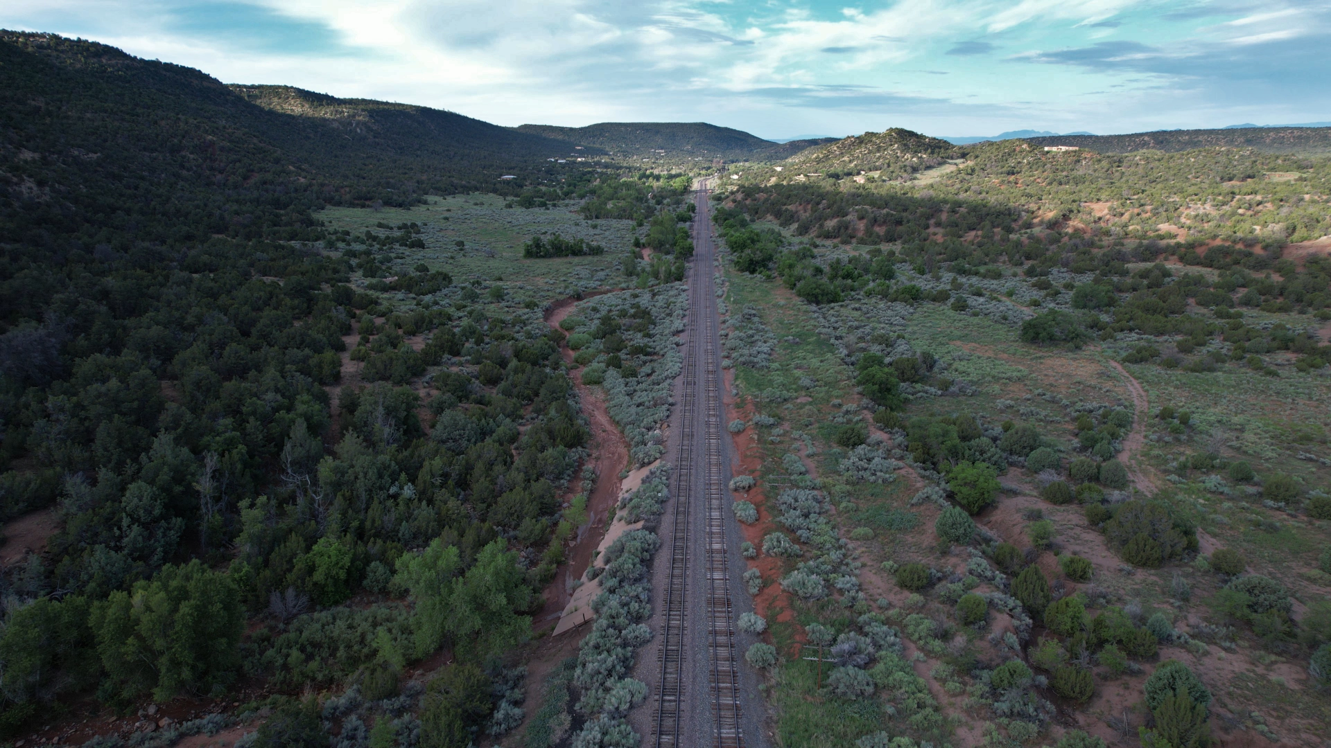
The most dramatic transformation of the Galisteo Creek landscape came with the arrival of the railroad in the 1870s. The Atchison, Topeka & Santa Fe Railway chose to build its line through Glorieta Pass, following roughly the same route that countless generations of travelers had used before.
As my drone captured footage of the modern railroad tracks that still carry Amtrak's Southwest Chief through this corridor, I was struck by the layers of history visible in a single frame. The steel rails represent the industrial age's conquest of distance and time, but they follow pathways first established by indigenous peoples and later worn deeper by Spanish colonizers and American traders.
The decision to route the railroad through Glorieta Pass was both practical and transformative. The pass offered the most feasible grade for steam locomotives struggling to cross the Sangre de Cristo Mountains, but it also meant that the railroad would bypass Santa Fe itself, leading to the establishment of Lamy as a junction point.
From my aerial vantage point, I could clearly see how the railroad's arrival reshaped settlement patterns throughout the region. Towns grew up around water stops and junction points, while others withered as the iron horse replaced wagon freight. The ancient pueblos along Galisteo Creek, already long abandoned, became even more isolated as the focus of regional transportation shifted to the railroad corridor.
The Lamy Connection
Watching my drone follow Galisteo Creek as it flows toward the small community of Lamy, I reflected on how this modest railroad town has served as a gateway to Santa Fe for more than a century. Named after Archbishop Jean-Baptiste Lamy—the French prelate who played such a significant role in New Mexico's territorial period—this junction point represents another layer in the complex history of this region.
The Southwest Chief still stops in Lamy twice daily, carrying passengers who often have no idea they're traveling through one of the most historically significant corridors in the American Southwest. As the train rounds the curves through Apache Canyon, passengers glimpse the same Galisteo Creek waters that sustained pueblo communities for centuries and later guided Spanish colonizers, Mexican traders, and American pioneers toward the markets of Santa Fe.
From above, the relationship between water, transportation, and settlement becomes crystal clear. The creek didn't just provide water—it provided the most logical route through challenging terrain, a fact that remains true whether we're talking about moccasined feet, wagon wheels, or steel rails.
The Galisteo Basin's Hidden Treasures
As my drone's battery began to run low, I guided it on one final pass over the area where Galisteo Creek opens into the broader basin that bears its name. From this perspective, the Galisteo Creek native American pueblo ruins scattered throughout the basin become part of a larger story about human adaptation to a challenging but beautiful environment.
The basin itself is a geological wonder—a broad, relatively flat expanse surrounded by mesas and mountains, drained by Galisteo Creek and its tributaries. This natural basin served as an oasis in the high desert, a place where water collected and where careful management could support substantial populations.
The pueblo ruins hidden throughout this landscape represent hundreds of years of architectural innovation and community development. Sites like Pueblo Galisteo, with its distinctive check-dam irrigation systems, show how successfully these communities managed their water resources. Other ruins reveal sophisticated understanding of solar orientation, wind patterns, and defensive positioning.
Many of these sites remain largely unexcavated, protected by their remote locations and the difficulty of accessing them without disturbing the archaeological record. Flying over the basin, I could see the subtle mounds and linear features that hint at buried structures, reminders that we've only begun to understand the full scope of pre-Columbian achievement in this region.
Pecos Pueblo: The Eastern Guardian
No discussion of this region's Native American heritage would be complete without acknowledging Pecos Pueblo, the massive ruins visible on a mesa overlooking the upper reaches of the Pecos River, just northeast of Glorieta Pass. While not directly on Galisteo Creek, Pecos served as the easternmost of the great Rio Grande pueblos and maintained extensive trade relationships with the Galisteo Basin communities.
From my aerial perspective, I could see how Pecos commanded the eastern approaches to the Santa Fe area, serving as both a trading post and a fortress. The pueblo's massive walls and strategic position made it one of the most important settlements in the pre-Columbian Southwest, and its eventual abandonment in 1838 marked the end of an era that had lasted more than 700 years.
The people of Pecos maintained their community far longer than most of the Galisteo Basin pueblos, adapting to Spanish rule and continuing to farm and trade well into the Mexican period. When they finally abandoned their ancestral home, the last residents moved to Jemez Pueblo, where their descendants still preserve aspects of Pecos culture and language.
A Modern Perspective on Ancient Wisdom
As I packed up my drone equipment in the warming morning air, I found myself thinking about the perspectives that age and experience bring to our understanding of landscape and history. At eighty-plus years, having witnessed tremendous changes in my own lifetime, I'm perhaps more aware than younger observers of how quickly things can change and how precious continuity becomes.
The Galisteo Creek native American pueblo ruins represent a kind of continuity that we're still learning to appreciate. These communities existed for centuries in relative harmony with their environment, developing sustainable practices that allowed them to thrive in a challenging landscape. Their eventual abandonment wasn't due to environmental degradation or resource depletion, but to the disruption caused by contact with European diseases and colonial systems.
My own journey from the Kansas Flint Hills to the mountains of New Mexico has taught me something about the importance of water in arid landscapes. On the ranch where I grew up, we understood that everything depended on precipitation and the careful management of whatever water we could capture and store. The pueblo builders along Galisteo Creek understood this truth at a much deeper level, creating agricultural systems that sustained large populations for generations.
The Digital Age Meets Ancient Stories
Drone photography and videography have revolutionized our ability to understand and appreciate landscapes like the Galisteo Creek corridor. From ground level, it's often difficult to see the patterns that become obvious from above—the relationship between water sources and settlement locations, the logic behind trail routes, the way topography channeled both human movement and natural processes.
The footage I captured this morning will become part of a growing digital archive that documents these important landscapes for future generations. In an age when development pressure threatens even remote areas, aerial documentation serves as both artistic expression and historical preservation.
But technology is just a tool. The real value lies in using these new perspectives to deepen our understanding of the human stories embedded in these landscapes. When I see the Galisteo Creek native American pueblo ruins from above, I'm not just documenting archaeological features—I'm trying to understand how thousands of people lived, worked, and thrived in this place for centuries.
Seasons of Change
Paulette and I have established our own rhythm in these later years, spending summers in Santa Fe and winters down at Lake Mohave in Arizona. This seasonal migration gives us a deep appreciation for how climate and weather patterns shape life in the Southwest. The pueblo builders along Galisteo Creek would have understood this rhythm intimately—the importance of summer growing seasons, the challenge of winter survival, the critical timing of spring snowmelt that fed the creek and recharged agricultural systems.
Climate change adds a new dimension to these ancient stories. As precipitation patterns shift and temperatures rise, the Galisteo Creek system faces challenges that the pueblo builders never had to contemplate. The creek that sustained communities for centuries now runs intermittently in many sections, its flow reduced by upstream diversions and changing weather patterns.
From our mountain home in Angel Fire, Paulette and I could see how quickly environmental conditions can change. Drought years stress the forest ecosystems that surround us, while heavy precipitation years can cause flooding and erosion. The pueblo builders developed strategies for dealing with natural variability, but the current rate of environmental change presents challenges that require new approaches to landscape management and cultural preservation.
Looking Forward, Honoring the Past
As the morning light grew stronger and I prepared to head back to Santa Fe, I took one last look across the landscape that had captivated me for the past several hours. The Galisteo Creek native American pueblo ruins scattered throughout this basin represent more than archaeological curiosities—they're reminders of human ingenuity, adaptability, and the complex relationships between people and place.
The drone footage I captured will join thousands of other images and videos in my digital collection, part of a lifetime's work documenting the landscapes of the American Southwest. But more than documentation, this work represents an attempt to understand and honor the layers of human experience that have shaped these places.
At my age, I'm acutely aware that we're all temporary residents in landscapes that have supported human life for millennia. The pueblo builders who thrived along Galisteo Creek for centuries understood something about sustainability and community that we're still trying to relearn. Their ruins stand as monuments to both human achievement and the fragility of civilization itself.
The morning flight over Galisteo Creek at Apache Canyon reminded me once again why Paulette and I chose to spend our retirement years in New Mexico. This is a landscape that rewards patient observation, that reveals its secrets gradually to those willing to spend time understanding its complexities. From the ancient pueblos to the modern railroad, from Spanish colonial settlements to contemporary communities, every layer adds depth to the story.
As the Southwest Chief rounds the curves through Apache Canyon twice each day, its passengers catch glimpses of this remarkable landscape. Most will never know they're traveling past some of the most significant archaeological sites in North America, places where the Galisteo Creek native American pueblo ruins continue to hold the secrets of centuries of human adaptation and achievement.
For those of us privileged to call this place home, the responsibility is clear: to document, preserve, and share these stories before time and change erase them forever. The morning light on Galisteo Creek reminds us that some things endure, that water still finds its way to the sea, and that the human stories embedded in these landscapes continue to teach us about resilience, community, and our place in the vast sweep of time.
In the end, that's what draws me back to places like this—the opportunity to witness and document the ongoing conversation between human ambition and natural forces, played out across landscapes that have seen it all before and will continue long after we're gone. The Galisteo Creek native American pueblo ruins stand as testament to that eternal dialogue, reminders that every generation must find its own way of living in harmony with the places that sustain us.


0 Comments