

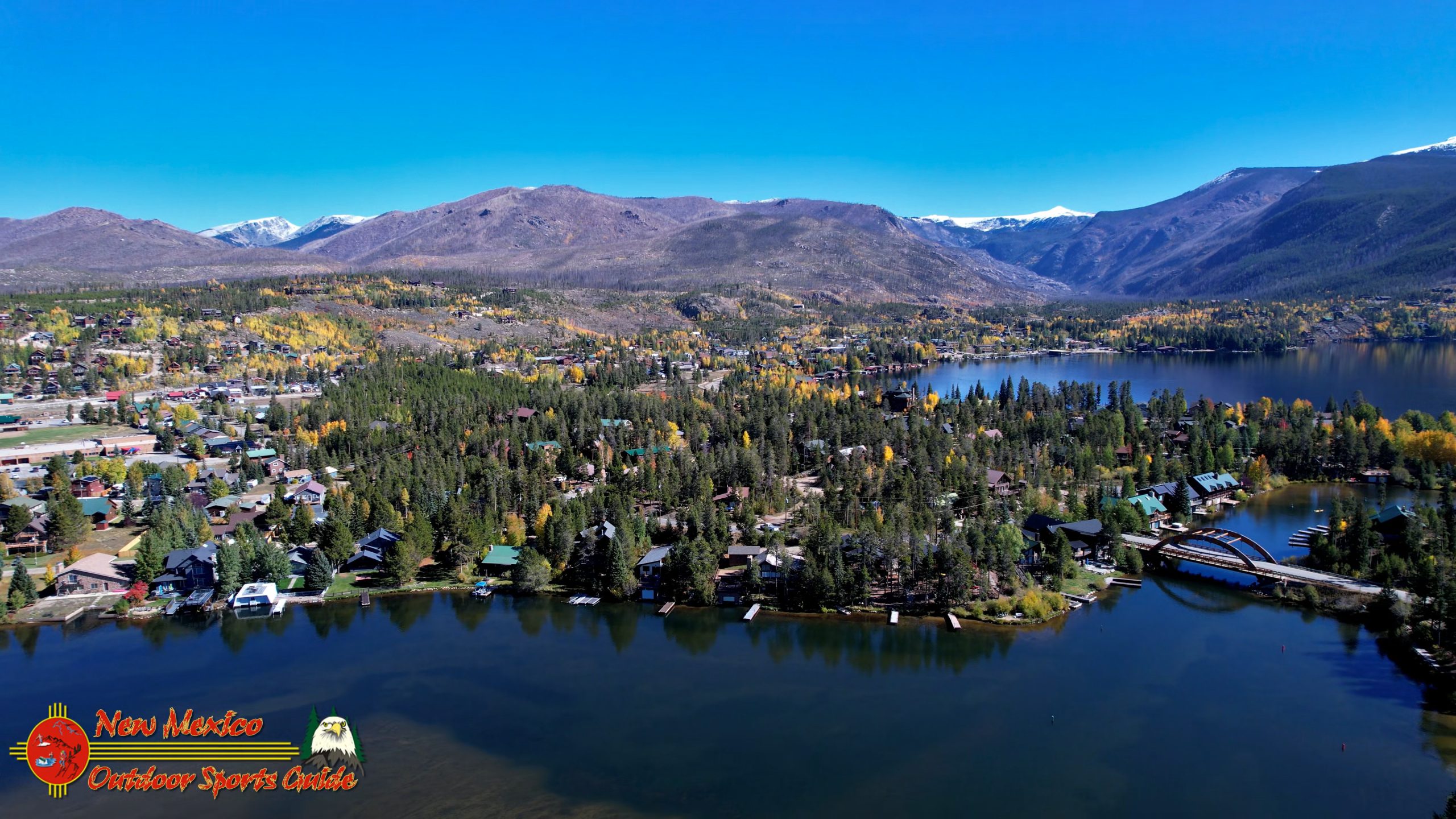
Aerial Perspective of Grand Lake
The morning air carried that particular crispness you only find at altitude in the Colorado high country—the kind that makes your coffee taste better and sharpens every edge of the mountain peaks against the impossibly blue sky. Paulette and I had been up in Grand County for several days now, chasing moose through the willows and exploring the birthplace of the Colorado River, and I found myself thinking that our adventure wouldn't be complete without capturing more of the remarkable water bodies that define this landscape.
Grand Lake had been calling to me since we arrived.
Planning the Perfect Flight
I've learned over eight decades that good photography—whether from the cockpit of a Beechcraft Baron at 8,000 feet or from a DJI drone at 400—requires planning. So over morning coffee, I pulled up online maps on my laptop and started scouting launch locations. The goal was simple: find a spot where I could send the drone up to capture Grand Lake in all its morning glory without disturbing the boaters who'd be out enjoying Colorado's deepest natural lake.
A parking area on the east end of Grand Lake looked promising. Good clearance, minimal obstructions, and positioned perfectly to capture both Grand Lake and its neighbor, Shadow Mountain Lake, in a single flight. After more than 2,600 hours of piloting aircraft, I've developed an instinct for reading terrain and planning flight paths—skills that translate surprisingly well to operating camera drones, even if the cockpit is now just a handheld controller.
The Colorado-Big Thompson Project: Engineering Marvel
After breakfast, we loaded our gear into the Outback and made the short drive to the east end parking area. The morning was shaping up to be one of those perfect Rocky Mountain days—not a cloud in the sky, the sun already warming the thin mountain air, and that sense of anticipation you get when you know the conditions are going to be ideal.
What we found at the parking lot stopped us in our tracks before we even thought about launching the drone.
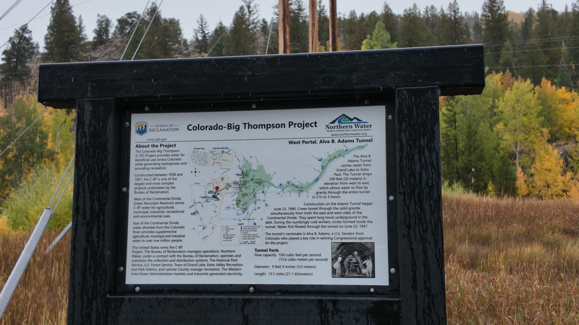
A sign stood in front of massive doors built directly into the mountainside—the entrance to the Colorado-Big Thompson Project. I'd read about this engineering feat before, but seeing the portal in person was something else entirely. The sign detailed an almost unbelievable achievement: a thirteen-mile tunnel bored straight through the Continental Divide to transport water from the west slope to the rapidly growing cities on Colorado's eastern plains.
Think about that for a moment. Thirteen miles through solid rock, through the backbone of the continent itself. The project was completed in the 1940s, an era when the technology we take for granted today didn't exist. Men with determination, dynamite, and an unwavering belief in engineering innovation carved this tunnel through the mountains, creating a system that would reshape water distribution in Colorado for generations.
Standing there in that parking lot, looking at those doors set into the mountain, I couldn't help but feel a connection to that kind of ambitious work. During my years running Centaur Installations, I learned that great projects require vision, persistence, and a willingness to tackle problems that seem impossible at first glance. The Colorado-Big Thompson Project embodied all of that on a scale that still boggles the mind.
Taking to the Sky
But the mountain tunnel would have to wait for deeper exploration another day. The morning conditions were too perfect to waste, and Grand Lake stretched out before us like a polished mirror.
I set up my drone on the edge of the parking lot, going through my pre-flight checklist with the same attention to detail I once applied to Baron preflight inspections. Battery charged? Check. GPS locked? Check. Return-to-home point set? Check. Wind conditions? Zero. The air was so still that I could hear the gentle lap of water against the rocky shore.
There's something almost spiritual about launching a camera drone on a morning like this. The little aircraft lifts off with that distinctive whine of electric motors, and suddenly you're not bound to the earth anymore. The perspective shifts instantly, and the world reveals itself in ways that are impossible to appreciate from ground level.
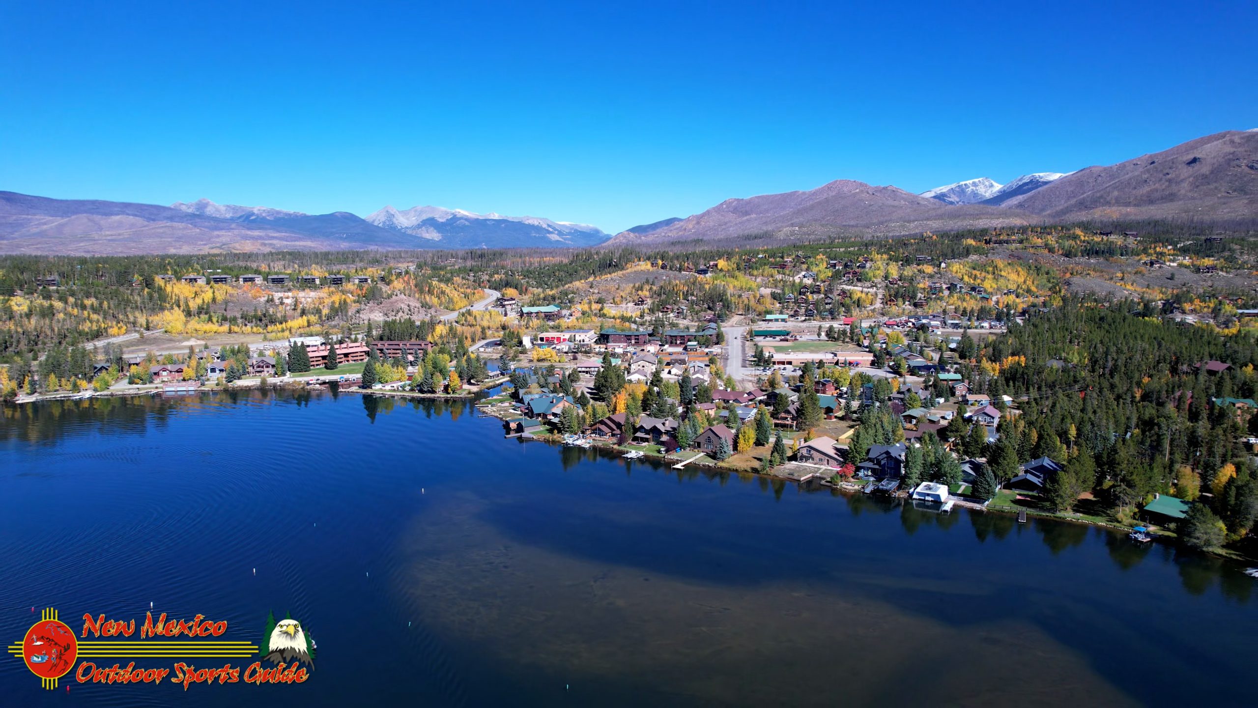
I pushed the control sticks forward gently, and the drone climbed into that cloudless blue Colorado sky. Below, Grand Lake spread out in all its magnificent glory—Colorado's largest and deepest natural lake, sitting at 8,369 feet above sea level. From my new aerial vantage point, I could see why Grand Lake has been called the "Soul of the Rockies."
The Eagle's Eye View
Flying a camera drone is the closest thing I've found to recapturing the pure joy I experienced during my years as a pilot. Back in my aviation days, flying the Baron from one construction site to another across America, I spent countless hours looking down at the landscape from a few thousand feet up. You see patterns and relationships between land and water, mountains and valleys, that simply don't register from the ground.
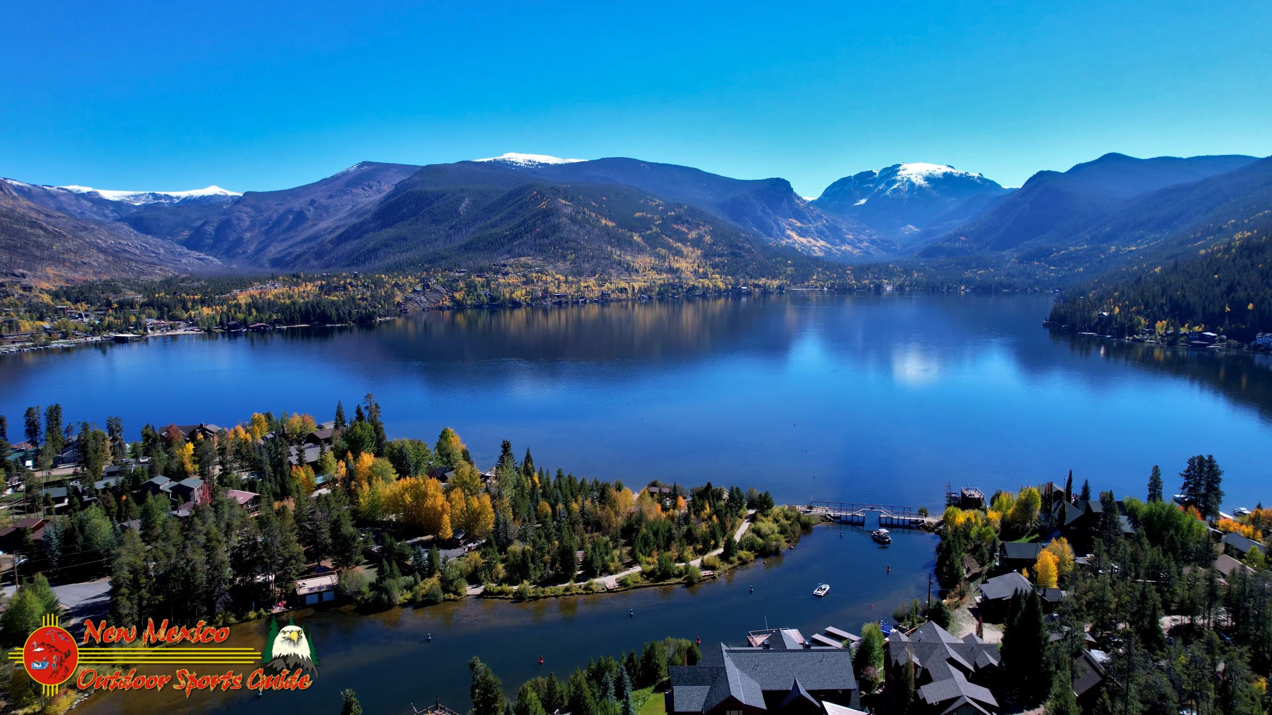
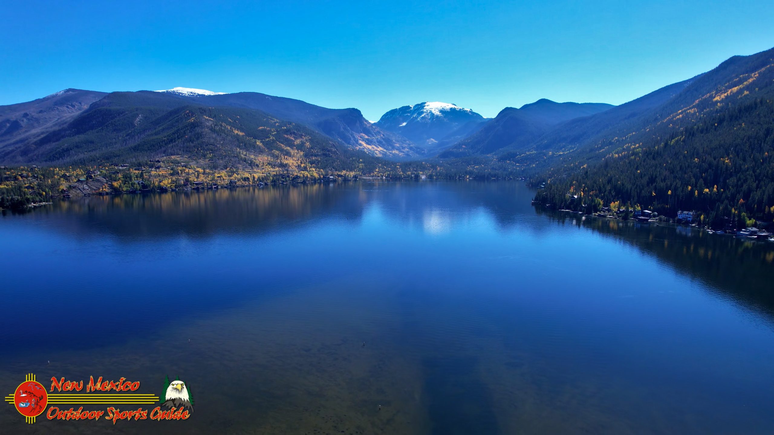
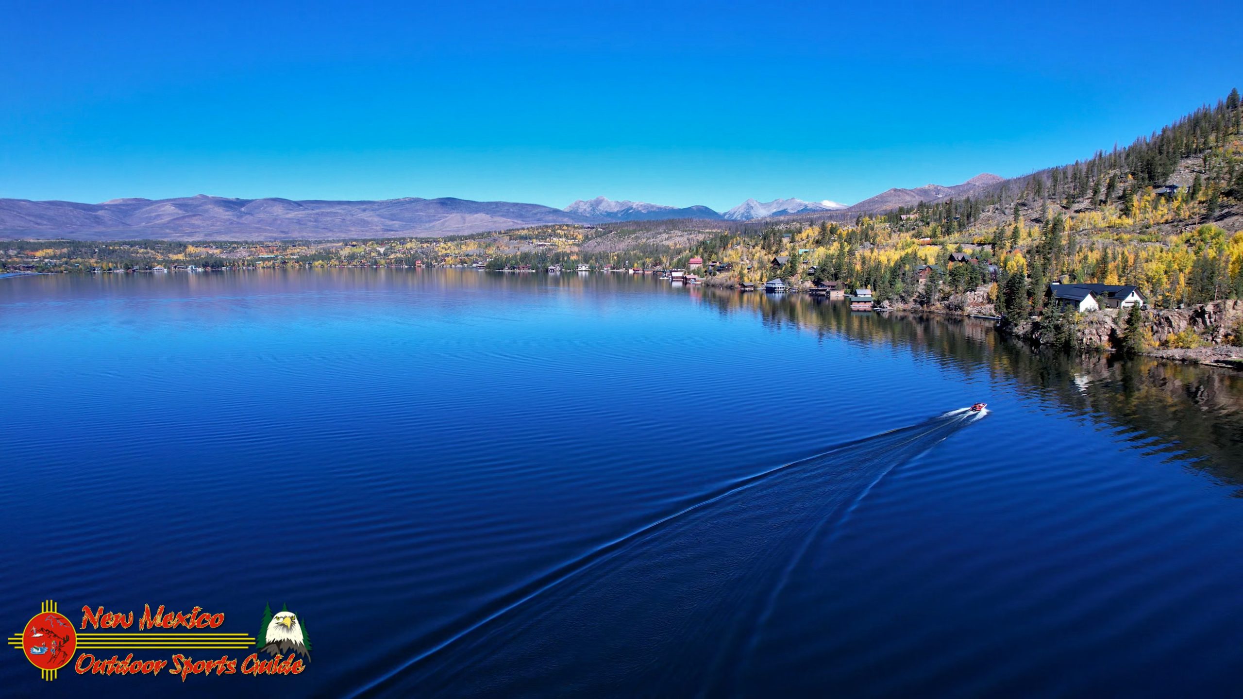
The drone crossed over the glassy surface of Grand Lake, and my screen showed the perfect reflection of the surrounding peaks in the water. This is why you fly early in the morning—before the winds pick up, before motorboats churn the surface into chop, before the afternoon thunderheads start building over the Continental Divide.
I guided the drone westward, watching as Shadow Mountain Lake came into view adjacent to Grand Lake. The two lakes are connected by a channel, part of that remarkable water management system that defines this region. From above, you could see how the canal links these bodies of water, creating a continuous aquatic highway.
The town of Grand Lake appeared on my screen—a classic Colorado mountain community with its buildings clustered near the western shore. Founded in the 1880s as a mining and ranching town, Grand Lake has evolved into a gateway community for Rocky Mountain National Park, maintaining its historic character while welcoming visitors from around the world. From my aerial perspective, I could see the careful way the town nestles against the landscape, respecting the mountains that surround it.
Respecting Privacy from Above
One of the responsibilities that comes with drone photography is respecting people's privacy. It's a lesson I carry from my journalism days at the University of Houston and reinforced by decades of working with people in various capacities. Just because technology allows you to peer into places doesn't mean you should.
When I fly, I'm conscious of where my camera points. I'm capturing landscapes, not invading private moments. The town of Grand Lake passed beneath my lens, but I kept the camera angle high and wide, focusing on the relationship between human settlement and natural environment rather than zooming in on individual properties or people.
This becomes particularly important in small mountain communities where people have chosen to live precisely because they value their privacy and connection to nature. The last thing I want to do is make someone feel like their sanctuary has been violated by a hovering camera.
The Ballet of Flight
I started panning the camera slowly across the town, taking in the layout of streets, the scatter of buildings that make up Grand Lake's commercial district, the boats moored at docks waiting for their owners to start the day. Then I brought the drone back eastward, beginning the return journey to my launch point.
The flight took me over the bridge that crosses the canal connecting Grand Lake and Shadow Mountain Lake—a narrow span that serves as a vital link in the local road system. From 300 feet up, I could see a couple of early-morning boaters already out on the water, their boats creating perfect V-shaped wakes that spread across the mirror-smooth surface like geometric patterns painted on glass.
These wakes fascinated me. They were the only imperfections on an otherwise flawless reflection of sky and mountains. The boats moved slowly, as if their operators also understood they were part of something beautiful this morning and didn't want to disturb it unnecessarily.
I flew the drone past houses lining the eastern shore—summer homes and year-round residences that enjoy what might be some of the most spectacular waterfront views in Colorado. The architecture varies from rustic log cabins to more modern mountain homes, but they all share that common element of mountain design: built to frame the views, to bring the outside in, to acknowledge that the landscape is the real star of the show.
Memories of Flying
As I watched the drone's progress on my controller screen, I found myself transported back to those years in the Baron. There's something about aerial perspective that changes how you understand a place. When you're on the ground, you experience geography sequentially—one valley, then a mountain pass, then another valley. But from above, you see the whole system at once. You understand how water flows, how communities connect, how the bones of the land dictate everything else.
I remember flying into mountain airports in Colorado, Utah, and New Mexico during my construction company days, threading the Baron through mountain passes, reading weather patterns in cloud formations, always calculating winds and density altitude. Those skills became second nature after 2,600 hours in the cockpit.
Drone flying requires the same spatial awareness, the same ability to read conditions and anticipate problems. The scale is different—a few hundred feet instead of several thousand—but the fundamental principles remain. Respect the machine, respect the environment, plan your flight, and always have an exit strategy.
A Perfect Day for Flying
The drone completed its circuit and began the final approach back to the parking lot. The return flight gave me another chance to appreciate the extraordinary beauty of Grand Lake from above. The water remained glasslike, that perfect mirror finish that photographers and videographers dream about but rarely encounter.
This is what you get when you're willing to rise early, when you plan carefully, when you respect the rhythms of mountain weather. By afternoon, thermal activity would probably kick up winds, and that mirror surface would transform into ripples and waves. But right now, in this perfect morning window, Grand Lake was showing off.
I brought the drone down smoothly, catching it just before touchdown in what pilots call a "greaser"—that perfect landing where you barely feel the contact with the ground. The flight had lasted perhaps twenty minutes, but I'd captured footage that would let me share this aerial perspective with others who might never have the chance to see Grand Lake from above.
Exploring Grand Lake Town
With the drone safely packed away and the morning still young, Paulette and I decided to take a brief tour of Grand Lake's main street before heading back to the cabin for lunch. The town has maintained much of its historic character despite the inevitable pressures that come with being a gateway to Rocky Mountain National Park.
Wooden boardwalks line portions of the main street, giving it that authentic frontier feel. The shops cater to both tourists and locals—outfitters selling fishing gear and hiking supplies alongside galleries featuring local art and restaurants serving everything from elk burgers to craft beer.
What struck me most about Grand Lake the town was how it seemed to understand its role. This isn't trying to be Aspen or Vail. It's a working mountain community that happens to sit in one of the most beautiful spots in Colorado. The people who live here year-round—enduring winters that can bury the town under feet of snow—have chosen this life deliberately, much like Paulette and I chose our years at Casa Oso in Angel Fire.
Afternoon Possibilities
As we drove back toward our cabin, I found myself already thinking about the afternoon. The weather forecast showed continued clear skies and light winds. If conditions held, Shadow Mountain Lake might offer another opportunity for aerial videography.
Shadow Mountain Lake is quite different from Grand Lake. It's a reservoir rather than a natural lake, created as part of the Colorado-Big Thompson Project to help regulate water flow and storage. But from the air, these distinctions matter less than the beauty of light on water, the pattern of shoreline against forest, the relationship between human infrastructure and natural landscape.
That's what draws me to aerial photography and videography in my eighties—the chance to see familiar places from new angles, to capture perspectives that weren't available to earlier generations, to document the American Southwest I've grown to love over decades of exploring.
Reflections on Technology and Time
Sitting here now, writing about that morning flight over Grand Lake, I'm struck by how technology has changed the nature of exploration and documentation. When I was learning to fly in Houston back in my twenties, aerial photography meant expensive cameras and film, complicated logistics, and often mediocre results unless you were a real expert.
Today, a relatively affordable drone and some practice can give anyone access to aerial perspectives that were once the exclusive domain of pilots and specialized photographers. I taught myself computer programming in the 1980s to build business software, and I taught myself HTML and web design in the 1990s to take advantage of the internet revolution. Now, in my eighties, I'm teaching myself drone operation and videography.
The learning never stops. That's one of the great gifts of a long life lived with curiosity—there's always something new to master, some new tool that opens up fresh possibilities.
The Gift of Grand Lake
Grand Lake—both the body of water and the community—represents something precious in modern America. In an era of increasing development and commercialization, places like this remind us what we stand to lose if we're not careful stewards of the land.
The Ute people knew this area as "Spirit Lake," and you can understand why. There's something almost otherworldly about the way the mountains cradle this water, the way morning light transforms the surface into liquid silver, the way the thin air seems to amplify colors and sharpen details.
The early settlers who came here in the 1800s, like my own Irish and German ancestors who eventually settled in Kansas, were drawn by opportunity but stayed because of something less tangible—a connection to place, a sense that certain landscapes speak to something deep in the human soul.
Looking Ahead
As I packed up the drone that morning and prepared to head back to the cabin, I knew that the footage I'd captured would become part of my ongoing project to document the Southwest through photography and video. These aerial perspectives of Grand Lake would join images of New Mexico's high desert, Arizona's red rock country, Utah's canyon lands, and Colorado's alpine wilderness.
This work has become my focus in these later years—creating a visual record of places I love, sharing perspectives that might inspire others to appreciate and protect these landscapes. Whether it's through the New Mexico Outdoor Sports Guide blog, YouTube videos, or conversations with fellow travelers, I'm trying to pass along not just images but also the sense of wonder that comes from truly seeing a place.
Grand Lake deserves that kind of attention. Colorado's largest and deepest natural lake, sitting at the headwaters of the mighty Colorado River, surrounded by peaks that scrape the sky—it's a place that rewards those who take the time to really look, whether from the shore, from a boat, or from 300 feet up with a camera drone.
The morning had given me everything I'd hoped for: perfect weather, glassy water, stunning light, and that indescribable feeling of flight. As we drove away from the east end parking lot, passing once more by those massive doors set into the mountainside, I made a mental note to return and learn more about the Colorado-Big Thompson Project.
But that would be another day, another adventure. For now, I had footage to review, lunch to enjoy with Paulette, and—if the weather held—perhaps another flight over Shadow Mountain Lake later in the afternoon.
The high country of Colorado had welcomed us once again, and Grand Lake had revealed itself in all its morning splendor. For an old ranch boy from Kansas who's spent a lifetime chasing experiences and documenting wild places, moments like these are what it's all about—the chance to see the world from new angles, to capture beauty that might otherwise go unnoticed, and to share it with others who love these mountains as much as I do.
Grand Lake. The name itself carries weight, suggesting something substantial and enduring. From my eagle's eye view that morning, I could confirm that the name is well-deserved. This is indeed a grand lake, in the best sense of that word—magnificent, impressive, and worthy of our respect and protection.
As we headed back to the cabin, I was already looking forward to whatever the afternoon might bring. In the high country, you learn to embrace each moment of good weather, each perfect morning, each opportunity to capture something special. You never know when conditions will change, when clouds will roll in, when wind will make flying impossible.
But that morning, at least, everything had aligned perfectly. Grand Lake had shown me its best face, and I'd been there with a camera drone to capture it. Sometimes, that's all you can ask for—to be in the right place at the right time, with the right tools and the right frame of mind to appreciate what you're seeing.
That's the gift Grand Lake gave me that morning, and it's a gift I'll carry with me long after the footage has been edited and shared. Some moments transcend the images they produce, becoming memories that sustain you through all the days to come.
This was one of those moments.


0 Comments